QMapControl
From Openmoko
| (5 intermediate revisions by 3 users not shown) | |||
| Line 1: | Line 1: | ||
| − | + | QMapControl is a "Qt Extended" (Qtopia) widget which enables your mobile applications to use map data. Simply add the widget to your application, have a look at the API and start developing a fancy geospatial mobile application. | |
| + | |||
| + | You can displays maps from WMS servers or tile servers like OpenStreetMap. Custom data can be added: points, lines, images or even other widgets like buttons. All those can be bound to a specific coordinate. | ||
A parser is included, which reads data from gllin. QMapControl is still in development, hopefully some people join the development. | A parser is included, which reads data from gllin. QMapControl is still in development, hopefully some people join the development. | ||
| Line 8: | Line 10: | ||
[[Image:Qmapcontrol.gif]] | [[Image:Qmapcontrol.gif]] | ||
| + | |||
| + | [[Category:GPS Applications]] | ||
| + | [[Category:Middleware]] | ||
Latest revision as of 09:52, 19 July 2009
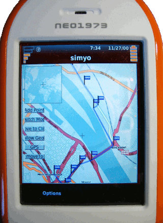
QMapControl is a "Qt Extended" (Qtopia) widget which enables your mobile applications to use map data. Simply add the widget to your application, have a look at the API and start developing a fancy geospatial mobile application.
You can displays maps from WMS servers or tile servers like OpenStreetMap. Custom data can be added: points, lines, images or even other widgets like buttons. All those can be bound to a specific coordinate. A parser is included, which reads data from gllin. QMapControl is still in development, hopefully some people join the development.
project website: http://www.medieninf.de/qmapcontrol/
project at sourceforge: http://sourceforge.net/projects/qmapcontrol

