TangoGPS
From Openmoko
| Line 1: | Line 1: | ||
{{Languages|TangoGPS}} | {{Languages|TangoGPS}} | ||
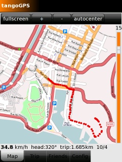
TangoGPS is a map application which can utilize Neo's built-in GPS to show your current location. | TangoGPS is a map application which can utilize Neo's built-in GPS to show your current location. | ||
| + | |||
| + | [[Image:TangoGPS1.jpg]] | ||
Website: http://www.tangogps.org | Website: http://www.tangogps.org | ||
| Line 24: | Line 26: | ||
Now you must power up the GPS-chip by opening the "Settings" application and setting the GPS entry to "on". Now you can run tangoGPS and wait until it get's a GPS fix. This can take up to a few minutes. | Now you must power up the GPS-chip by opening the "Settings" application and setting the GPS entry to "on". Now you can run tangoGPS and wait until it get's a GPS fix. This can take up to a few minutes. | ||
| − | == Downloading Maps offline use == | + | == Downloading Maps for offline use == |
tangoGPS can bunch-download the map images so you don't need an internet connection while walking around. By default tangoGPS stores downloaded maps to /tmp/. This folder is lost every time you reboo the device. But you can use the "Config" tab within tangoGPS to change the "Cache Dir" location to , for example, /osm/ . So downloaded maps will be kept in the Neos flash, also after reboot. Unfortunately this configruation is lot every time you restart tangoGPS. So every time you start tangoGPS you have to go to this Config tab and set the correct location. | tangoGPS can bunch-download the map images so you don't need an internet connection while walking around. By default tangoGPS stores downloaded maps to /tmp/. This folder is lost every time you reboo the device. But you can use the "Config" tab within tangoGPS to change the "Cache Dir" location to , for example, /osm/ . So downloaded maps will be kept in the Neos flash, also after reboot. Unfortunately this configruation is lot every time you restart tangoGPS. So every time you start tangoGPS you have to go to this Config tab and set the correct location. | ||
Revision as of 13:14, 17 August 2008
| Languages: |
English • العربية • Български • Česky • Dansk • Deutsch • Esperanto • Eesti • Español • فارسی • Suomi • Français • עברית • Magyar • Italiano • 한국어 • Nederlands • Norsk (bokmål) • Polski • Português • Română • Русский • Svenska • Slovenčina • Українська • 中文(中国大陆) • 中文(台灣) • Euskara • Català |
TangoGPS is a map application which can utilize Neo's built-in GPS to show your current location.
Website: http://www.tangogps.org
Running tangoGPS on OM2008.8
| NOTE: There may be other steps because I remember it took a while before my TangoGPS started working, but these are the only things I remember installing |
From the freerunner connected to the internet:
 opkg install gpsd
 opkg install tangogps
If opkg complains about not being able to acquire a lock, try:
pkill packagekit
To get gpsd working on the Freerunner you have to change the configuration according to Gpsd#GPS_on_GTA02. Then start gpsd by:
/etc/init.d/gpsd start
Now you must power up the GPS-chip by opening the "Settings" application and setting the GPS entry to "on". Now you can run tangoGPS and wait until it get's a GPS fix. This can take up to a few minutes.
Downloading Maps for offline use
tangoGPS can bunch-download the map images so you don't need an internet connection while walking around. By default tangoGPS stores downloaded maps to /tmp/. This folder is lost every time you reboo the device. But you can use the "Config" tab within tangoGPS to change the "Cache Dir" location to , for example, /osm/ . So downloaded maps will be kept in the Neos flash, also after reboot. Unfortunately this configruation is lot every time you restart tangoGPS. So every time you start tangoGPS you have to go to this Config tab and set the correct location.
Once you have set the location to a non-volatile path, you can connect your Neo to the internet by USB or WiFi at home and start downloading the maps of your area. Tap the map screen and select "map download". Now on-the-road tangoGPS will be able to show you maps in different zoom levels even though you are not connected to the inet.
Downloading Maps via GPRS
I think TangoGPS may have started working after I followed the instructions to get GPRS working with GSM multiplexing here: Manually_using_GPRS#Option_1:_With_GSM_multiplexing_and_with_a_GUI
There are steps included in those instructions to improve GPS performance. The great thing is that once you get GPRS working, you can roam with TangoGPS running and have it download maps as needed over the GPRS connection!

